Various Singapore Map
To understand Singapore property, we can start with Understanding Singapore map. You can find various Singapore Map, including District map, Opportunity Map, Expressway Map, MRT line Map.
District Map
We starts with Singapore area district. In the past, our Singapore postal is 4 digit, example Jurong East is 2260, people uses the 1st 2 digit of the postal code to draw an invisible boundary, therefore, Jurong came to known as district 22.
This format created a total of 28 district, of which district 9, 10 ,11 is the prime district and is highly sought after; especially liken by foreigner.
Some people may get confuse on the district, therefore, We have classified them into zone for easy reference.
- Light Grey = North,
- Green = South,
- Dark Grey = East,
- Blue = West,
- Red = Middle,
- Yellow = North East
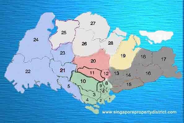
Singapore District map
| District 1 | Boat Quay, Chinatown, Havelock Road, Marina Square, Raffles Place, Suntec City |
| District 2 | Outram Park, Tanjong Pagar, Chinatown, Mainly the CDB area |
| District 3 | Tiong Bahru, Alexandra, Queenstown, Bukit Merah |
| District 4 | Mount Faber, Telok Blangah, Harbourfront, Sentosa Island |
| District 5 | Buona Vista, Pasir Panjang, Clementi, West Coast, Dover |
| District 6 | Clarke Quay, City Hall, beach Road, City Hall, High Street |
| District 7 | Bugis, Beach Road, Golden Mile, Bencoolen Street, Middle Road |
| District 8 | Little India, Farrer Park, Kitchener Road, Serangoon road |
| District 9 | Orchard Road, River Valley, Killiney |
| District 10 | Bukit Timah, Holland, Balmoral, Farrar Park, Holland Village, Tanglin |
| District 11 | Novena, Newton, Thomson |
| District 12 | Toa Payoh, Serangoon, Balestier, Potong Pasir, Upper Aljunied |
| District 13 | Macpherson, Braddell, Potong Pasir |
| District 14 | Geylang, Paya Lebar, Sims, Eunos, Kembangan |
| District 15 | Joo Chiat, Marina Parade, Katong, Tanjong Rhu, Telok Kurau |
| District 16 | Bedok, Upper East Coast, Siglap, Chai Chee |
| District 17 | Changi, Flora, Loyang |
| District 18 | Tampines, Pasir Ris, Simei |
| District 19 | Punggol, Sengkang, Serangoon Gardens, Hougang |
| District 20 | Ang Mo Kio, Bishan, Thomson, Sin Ming |
| District 21 | Upper Bukit Timah, Ulu Pandan, Clementi Park |
| District 22 | Boon Lay, Jurong, Tuas, Pandan Garden, Teban Garden |
| District 23 | Choa Chu Kang, Diary Farm, Hillview, Bukit Panjang, Bukit Batok |
| District 24 | Kranji, Lim Chu Kang, Tengah |
| District 25 | Woodlands, Admiralty, Senoko, Kranji |
| District 26 | Upper Thomson, Mandai, Yio Chu Kang |
| District 27 | Sembawang, Yishun, Admiralty |
| District 28 | Yio Chu Kang, Seletar |
Singapore MRT Line Map
From just the Red line since 7 November 1987, it had increases to many different line servicing the whole Singapore population.
Our government usually plans the infrastructure ahead of any residential development in new area. Or any enhanced development to due with their projected 6.5 million population. The projection is by 2030, to let 80% of the home to have a MRT station within 10 mins of walk.

MRT map 2014
Singapore Expressway Map
As you can see from the Singapore Expressway Map below, travelling using the expressway from East to West may only take 40 minutes on ideal road condition.
Some of the expressway may needs to pay Electronic Road Pricing (ERP) at certain timing to ease congestion. Therefore, government is also planning more expressway like Marina Coastal Expressway had add to the existing expressway in 29 December 2013. Coming up will be North South Expressway which is expected to operate in 2020 measuring 21 km.
Singapore is also an important Transport Hub to support our busy Port of Singapore Authority (PSA) Therefore a good healthy system is very important.

Singapore Expressway Map
Sponsor site : www.sgtruck.com
Opportunity Map
Knowing where is the concentration of Industrial and Commercial land can help us decide on our strategy in investment.
Those in Yellow is Industrial land with the biggest sector in the West follow by the East. The next up and coming Industrial area will be in the North as announced by the government.
Commercial area that is indicated in blue will always be in the Core Central area which is the CBD. Government plan is to diversified the commercial area so as to keep rental competitive and reduce travelling time for the people. So as to have a well balance work and family life.

Industrial and Commercial Opportunity Map
We will be adding more different map on top of those various Singapore map available, do come back and check it out. Meanwhile. do check out some of the fine selection of property in Singapore.
Share this wonderful property Twitter and Google+.